You are using an out of date browser. It may not display this or other websites correctly.
You should upgrade or use an alternative browser.
You should upgrade or use an alternative browser.
Los Angeles Brush Fire 1/7/25
- Thread starter EMSR2
- Start date
- Joined
- Apr 1, 2007
- Messages
- 4,308
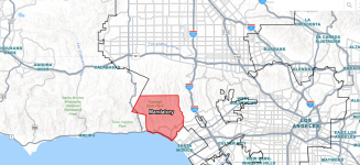
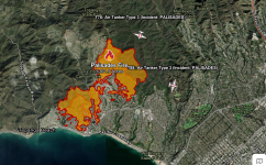
A major 300 acre brush fire is burning in the City of Los Angeles, threatening the Topanga Canyon and Pacific Palisades areas. Mandatory evacuations have been ordered for the area shown in the map (LAFD photo). Santa Ana winds have been blowing at up to 80 mph, and forecast to rise to as much as 100 mph tonight in the higher elevations. The fire grew from approximately 20 acres this morning at 10:30 PST to more than 300 acres at 12:30 PST (15:30 Eastern).
LA CITY FD units assigned as of 12:30 PST: FS 23; Batt 9; West Bureau; Council District 11; AO1 AO2 AR1 AR11 BC4 BC701 BC705 BC706 BC717 BC9 BP19 CM40 CM42 CM51 CM52 DZ42 DZ45 E1 E105 E12 E14 E15 E17 E19 E1B E20 E23 E237 E26 E263 E269 E27 E29 E292 E3 E37 E38 E3S E4 E41C E43 E43C E5 E59 E61 E62 E63 E64 E66 E67 E68 E69 E6S E70 E71 E73 E75 E8136 E8137 E8138 E8139 E8140 E85 E90 E93 E94 E98 EM17 EM9 H1 H2 H3 H4 H7 HA1 HA2 HA3 HA4 HA7 HE1 HT3 PB1880 PH1 RA19 RA23 RA37 RA69 RA92 SO1 SU4 T37 T63 T69 WT77; CH5
In case you didn't care to count, that's 50 engine companies assigned.

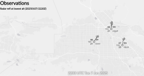
KWHP is Whiteman Airport in Los Angeles, with KBUR being Burbank and KVNY being Van Nuys. The plot shows that the surface winds at Whiteman are 45 KNOTS (51 mph), gusting to 68 KNOTS (78 mph). Perfect weather for fighting a brush fire (NOT).

Ray Braguglia
Newport News VA
View attachment 47354
LA CITY FD units assigned as of 12:30 PST: FS 23; Batt 9; West Bureau; Council District 11; AO1 AO2 AR1 AR11 BC4 BC701 BC705 BC706 BC717 BC9 BP19 CM40 CM42 CM51 CM52 DZ42 DZ45 E1 E105 E12 E14 E15 E17 E19 E1B E20 E23 E237 E26 E263 E269 E27 E29 E292 E3 E37 E38 E3S E4 E41C E43 E43C E5 E59 E61 E62 E63 E64 E66 E67 E68 E69 E6S E70 E71 E73 E75 E8136 E8137 E8138 E8139 E8140 E85 E90 E93 E94 E98 EM17 EM9 H1 H2 H3 H4 H7 HA1 HA2 HA3 HA4 HA7 HE1 HT3 PB1880 PH1 RA19 RA23 RA37 RA69 RA92 SO1 SU4 T37 T63 T69 WT77; CH5
In case you didn't care to count, that's 50 engine companies assigned.

Example of the winds now blowing near the fire:KWHP is Whiteman Airport in Los Angeles, with KBUR being Burbank and KVNY being Van Nuys. The plot shows that the surface winds at Whiteman are 45 KNOTS (51 mph), gusting to 68 KNOTS (78 mph). Perfect weather for fighting a brush fire (NOT).

Ray Braguglia
Newport News VA
View attachment 47354
- Joined
- Apr 1, 2007
- Messages
- 4,308
LAFD Update as of 1723 Eastern:
Update Brush Fire 01/07/2025 INC#0738
Update Brush Fire; INC#0738; 02:23PM; 1190 N Piedra Morada Dr; https://bit.ly/3PqUKVq; Pacific Palisades; After an aerial mapping, the size of the fire is updated to 770 acres. The evacuation zone remains unchanged and can be seen in the map linked above. There are over 250 LAFD firefighters in addition to neighboring agencies. Approximately 30 vehicles left abandoned on Sunset and Palisades will be moved by County dozer to provide clear access. Westwood Recreation Center is available as both an evacuation center and overnight shelter for evacuees and small animals. For the latest information, please visit https://lafd.org/news/palisades-fire-0; FS 23; Batt 9; West Bureau; Council District 11; AO1 AO2 AP43 AR1 AR11 AR33 AR34 BC4 BC701 BC705 BC706 BC717 BC721 BC9 BP109 BP19 BP74 BP8 BP99 CM40 CM42 CM51 CM52 DZ42 DZ45 E1 E105 E12 E14 E15 E17 E19 E1B E20 E23 E237 E26 E263 E269 E27 E29 E292 E3 E37 E38 E3S E4 E41C E43 E43C E5 E59 E61 E62 E63 E64 E66 E67 E68 E69 E6S E70 E71 E73 E75 E8136 E8137 E8138 E8139 E8140 E85 E90 E93 E94 E98 EA1 EA2 EM17 EM9 FR115 H1 H2 H3 H4 H7 HA1 HA2 HA3 HA4 HA7 HE1 HT3 PB1880 PH1 RA19 RA23 RA37 RA69 RA92 SO1 SU4 T37 T63 T69 WT77; CH5; 1 2; Margaret Stewart
- Joined
- Nov 1, 2019
- Messages
- 604
Serious question here. Do they not do controlled burns? We do them here in the south to burn off the dead underbrush to attempt to prevent this. Whenever I see pictures of parts of California, I always see tons and tons of dead underbrush
- Joined
- Sep 3, 2024
- Messages
- 124
Look who's running that state, There's the answerSerious question here. Do they not do controlled burns? We do them here in the south to burn off the dead underbrush to attempt to prevent this. Whenever I see pictures of parts of California, I always see tons and tons of dead underbrush
- Joined
- Apr 1, 2007
- Messages
- 4,308
LAFD Update as of 1930 Eastern:
Update Brush Fire 01/07/2025 INC#0738
Update Brush Fire; INC#0738; 04:30PM; 1190 N Piedra Morada Dr; https://lafd.maps.arcgis.com/apps/Media/index.html?appid=ba8cfed4b4a04d49b7489eb8300727a8; Pacific Palisades; The fire is now 1262 acres and growing due to the extreme wind conditions. The winds are anticipated to peak in the overnight hours. The Mandatory Evacuation zone remains the same and encompasses most of Pacific Palisades. Interactive map link for the evacuation zone is provided above. Westwood Recreation Center (1350 S Sepulveda Blvd 90025) is open (overnight as well) and accepts small animals. Large animal evacuation center is Pierce College (6201 Winnetka Ave, 91367). For any residents not in but near to the evacuation zone, please ensure you are prepared for a possible evacuation. For the latest updates: https://lafd.org/news/palisades-fire-0; FS 23; Batt 9; West Bureau; Council District 11; AO1 AO2 AP43 AR1 AR11 AR33 AR34 BC4 BC701 BC705 BC706 BC717 BC721 BC9 BP109 BP19 BP23 BP74 BP8 BP84 BP99 CM40 CM42 CM51 CM52 CW3A DZ41 DZ42 DZ45 E1 E105 E12 E14 E15 E17 E19 E1B E20 E221 E23 E237 E26 E263 E269 E27 E29 E290 E292 E3 E33 E37 E38 E39 E3S E4 E41C E43 E43C E5 E59 E61 E62 E63 E64 E66 E67 E68 E69 E6S E70 E71 E73 E75 E8136 E8137 E8138 E8139 E8140 E82C E85 E90 E93 E94 E95 E98 EA1 EA2 EM17 EM9 FR115 H1 H2 H3 H4 H7 HA1 HA2 HA3 HA4 HA7 HE1 HT2 HT3 PB1880 PH1 PI1 RA19 RA23 RA37 RA56 RA69 RA862 RA867 RA92 SO1 SU4 T21 T37 T63 T69 T90 WT77 WT88; CH5; 1 2; Margaret Stewart
- Joined
- Apr 1, 2007
- Messages
- 4,308
CalFire has taken over Unified Command for this incident, with resources from CAL FIRE San Bernardino-Inyo-Mono Unit, Los Angeles County Fire Department, Los Angeles City Fire Department and Los Angeles Police Department.
- Joined
- Jun 27, 2017
- Messages
- 1,508
Santa Ana winds occur whenever there is a high pressure center over the Great Basin in Utah. The clockwise rotation produces winds driven into Southern California. As the surface winds are forced through the narrow mountain passes wind speeds accelerate. Air traveling over the mountains lose moisture and cool, increasing density. As the dense air falls over the mountain peaks into SoCal it is compressed producing adiabatic heating. The end result is high winds with hot, spectacularly dry air.
The ground cover of SoCal is known as chapparal. These are several plants that are able to grow in an arid climate. The majority of the living plant is below the surface. Everything above ground is dead. So, it is easily combustible and the heat content per acre is compared to thousands of gallons of gasoline.
The stage is now set.
Last edited:
- Joined
- Sep 3, 2024
- Messages
- 124
These Santa Ana winds are the opposite of Chinook winds. The Chinook winds are the winds that come down the easter slopes of the mountains, compress and warm up and can produce the same disastrous events. I hate to say it but this will burn right down to the Pacific ocean.Santa Ana winds occur whenever there is a high pressure center over the Great Basin in Utah. The clockwise rotation produces winds driven into Southern California. As the surface winds are forced through the narrow mountain passes wind speeds accelerate. Air traveling over the mountains lose moisture and cool, increasing density. As the dense air falls over the mountain peaks into SoCal it is compressed producing adiabatic heating. The end result is high winds with hot, spectacularly dry air.
The ground cover of SoCal is known as chapparal. These are several plants that are able to grow in an arid climate. The majority of the living plant is below the surface. Everything above ground is dead. So, it is easily combustible and the heat content per acre is compared to thousands of gallons of gasoline.
The stage is now set.
The only thing one can do is have your evac plan and get out of the way.
just wondering if the governor of california took money from trimming the under brush and pruning problematic vegetation which would prevent or limit fuel for these type of fires and allocated it to illegal immigration.... just throwing it out there
thoughts and prayers for those in jeopardy.
thoughts and prayers for those in jeopardy.
- Joined
- Apr 25, 2008
- Messages
- 720
Does anyone know if the LA County area has a webpage similar to this?
- Joined
- Sep 25, 2013
- Messages
- 994
Los Angeles County FD units also workingCalFire has taken over Unified Command for this incident, with resources from CAL FIRE San Bernardino-Inyo-Mono Unit, Los Angeles County Fire Department, Los Angeles City Fire Department and Los Angeles Police Department.
1190 PIEDRA MORADA DR, CA
E9 E65 E67 E68 E69 E70 E88 E89 E125 E565
WT70
S88
P65 P69 P70
AC7 AC41 BC5 BC23 DC9
CC12A CC12B CC22 CC23 CC82 CC83 CC84 CC131
COPT11 COPT17 COPT18 COPT76
DZ5
SU8 SU12 SU16 SU20 SU21
TRAN7
U10 U16
AA52 BRU BWDR
CN17 COML8
FIRE4
HT5 HTNK55
LG272
QB1 QB2
SECT5
SO1 SO5 SO10 SO20 SO30
TANKER02 TANKER41
1:38 PM
- Joined
- Apr 1, 2007
- Messages
- 4,308
2921 Acres as of 0340 EST. LA City now has 71 engine companies committed to this fire. This is more than half of the departments engine companies. According to Governor Newsome, there are now more than 1400 first responders committed to this fire. To make matters worse, more fires have started. The Hurst fire in the Sylmar area grew from 50 acres to 500 acres in just under 4 hours overnight.
Last edited:
- Joined
- Mar 30, 2023
- Messages
- 968
I saw a video awhile back about the Eucalyptus Tree, mostly found in the south western pacific, but also found in California and several European countires. Apparently it produces a oil that is highly flammable. Anybody know if these trees are found in areas that are burning?
I wouldn’t be surprised. They reappropriated similar funds prior to the Paradise fire some years ago.just wondering if the governor of california took money from trimming the under brush and pruning problematic vegetation which would prevent or limit fuel for these type of fires and allocated it to illegal immigration.... just throwing it out there
thoughts and prayers for those in jeopardy.

