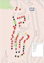
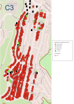
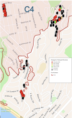
Maps of current LA County Wildfire Structural Fire Damage Assessment

Joined
Sep 7, 2020
Messages
2,220
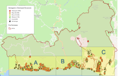
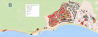
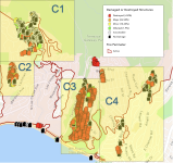
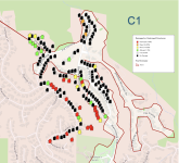
I clipped, copied and pasted maps and map sections from source mentioned in this NY Post article, I broke the affected area down into Sectors A, B, C. Sector C area was a large area and was difficult to see detail...so I broke them down further into maps Division C1, C2, C3, and C4. I also include the color coding map legend on each map.


Screenshot 2025-01-13 at 3.29.25 PM.png

Screenshot 2025-01-13 at 3.30.08 PM.png
Screenshot 2025-01-13 at 3.30.28 PM.png

Screenshot 2025-01-13 at 3.29.48 PM.png


Screenshot 2025-01-13 at 3.30.44 PM.png

Screenshot 2025-01-13 at 3.31.00 PM.png
Screenshot 2025-01-13 at 3.31.13 PM.png

Screenshot 2025-01-13 at 3.31.33 PM.png
 

Attachments

  • Screenshot 2025-01-13 at 3.30.08 PM.png
    Screenshot 2025-01-13 at 3.30.08 PM.png
    425.5 KB · Views: 3
I clipped, copied and pasted maps and map sections from source mentioned in this NY Post article, I broke the affected area down into Sectors A, B, C. Sector C area was a large area and was difficult to see detail...so I broke them down further into maps Division C1, C2, C3, and C4. I also include the color coding map legend on each map.


View attachment 47531

View attachment 47534
View attachment 47535

View attachment 47532


View attachment 47536

View attachment 47537
View attachment 47538

View attachment 47539
Very nice job presenting the data.

It will be interesting to see an analysis of the construction characteristics of structures that survived, particularly ones that were surrounded by those destroyed.
 
Very nice job presenting the data.

It will be interesting to see an analysis of the construction characteristics of structures that survived, particularly ones that were surrounded by those destroyed.
Agreed. I am curious as well why some burned to the ground and others next door didn’t.
 
One thought could be: Maybe those that survived are newer buildings, with better construction materials, and those that mostly burnt down could be older construction with less fire-proof materials.
 
Lets give consideration to wind shifts & possible water drops. I remember super storm Sandy which destroyed over 100 homes in the Rockaway community.
Some homes were totally destroyed & the ones right next to was never touched by fire.
 
Last edited:
Lets give consideration to wind shifts & possible water drops. I remember super storm Sandy which destroyed over 100 homes in the Rockaway community.
Some homes were totally destroyed & the ones right next to was never touched by fire.
Although there are clearly many important variables, the only one under the control of the homeowner (and the insurance company) is home construction and adjacent landscaping. Like hurricane roof straps in Florida, I'm sure the State of California will have a say too.

After the Great Fire of London in September 1666, Parliament passed the Rebuilding Act mandating that homes have brick walls, fire-resistant interior partitions, and tile or slate roofs.

In Manhattan, aren't frame buildings prohibited? Also, the wide east-west thoroughfares (Canal, Houston, 14th, etc.) were built to act as fire breaks, and not, as everyone assumed, a great place to double and triple park.
 
Back
Top