You are using an out of date browser. It may not display this or other websites correctly.
You should upgrade or use an alternative browser.
You should upgrade or use an alternative browser.
Remnants of Ida Updates/Incidents
- Thread starter rangermsg1
- Start date
Flooding in Bronx on Major Deegan Xpwy @ W. 230 St. @ approx. 03:45 hrs.
E81
L46
S41
S61
Hi-Axle1
B27
TAC1
E81 requested Hi-Axle1 to respond to assist in removal of stranded motorists in flooded section of the highway.
Hi-Axle1 removed 15 motorists.
E81 requested MERV unit to respond to assess motorists who were stranded in water for an extended period of time (hope nobody is offended by use of the word "stranded" to describe motorists).
S41 has boat w/2 members in water searching approx. 20 vehicles, will be an extended operation.
BxD reports that MERV unit is responding.
S41 requests an additional unit w/boat to respond to assist in searching multiple vehicles- S61 assigned.
B27 reports that S41 is searching south side of highway/S61 is searching north side of highway - duration is 1hr./48 min.
Last edited:
- Joined
- Apr 13, 2012
- Messages
- 9,724
Reported 12 dead across NYC due to storm and flooding. Included in those are the at least 2 structure floodings in Queens.
- Joined
- May 6, 2010
- Messages
- 17,412
The strip of Utopia Pkwy that 299/152 is on has had problems on & off for many years.....from the LIE going South on Utopia is a low lying area for several blocks ....i have seen sewer covers pushed off & parked cars floated onto lawns & basement apts flooded .....several years ago there was a big sewer upgrade that was supposed to alleviate the flooding but i guess the large amount of water this time was too much....... 61-20 utopia parkway, flushing, nyE299 reports E299/TL152 quarters are flooded…BC52 is 10-84
Last edited:
- Joined
- Jan 16, 2009
- Messages
- 2,944
Also anyone familiar with Glendale and Middle Village the underpass had atleast 10 feet off of water. Searches for cars / civilian were made on each side TL 135 on Glendale side and 319 on Middle Village side. Thank God negative. This also cause a long response for 319 /286 & 135 to go 80 St to Myrtle vise a versa.The strip of Utopia Pkwy that 299/152 is on has had problems on & off for many years.....from the LIE going South on Utopia is a low lying area for several blocks ....i have seen sewer covers pushed off & parked cars floated onto lawns & basement apts flooded .....several years ago there was a big sewer upgrade that was supposed to alleviate the flooding but i guess the large amount of water this time was too much....... 61-20 utopia parkway, flushing, ny
I remember as a kid in 1966 thru 69 when the underpass flooded the train tracks area was a dumping ground for a/c s...refrigerators.. tires ect. On the was to JHS 119 we cut school and whatever could be found was thrown off the tracks and down into the flood. Floods havent changed but no more junk is dumped near tracks so nobody throws stuff anymore
Last edited:
- Joined
- Jun 27, 2017
- Messages
- 1,508
Are basement apartments ever legal? If so, what egress is required? Wonder what guidelines the MTA has for ceasing or modifying operations during flooding events?
In Harris County, Texas, there are 170 rain gauges generating real time data on the internet (www.hcfcd.org). When a gauge records one inch of rain in 15 minutes, a local flood warning is generated for a three mile radius.
In Harris County, Texas, there are 170 rain gauges generating real time data on the internet (www.hcfcd.org). When a gauge records one inch of rain in 15 minutes, a local flood warning is generated for a three mile radius.
- Joined
- Apr 1, 2007
- Messages
- 4,307
- Joined
- Jun 27, 2007
- Messages
- 3,722
There never was a description of what catastrophic flooding was, correct?
- Joined
- Jun 27, 2017
- Messages
- 1,508
Any flood that YOU are in is catastrophic.
- Joined
- May 6, 2010
- Messages
- 17,412
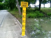
During Sandy the "NO STANDING" St signs along Beach Channel Drive in Rockaway were used to judge the approximate water level from a distance......those actual numbers on the poles in Texas are a big help to further pinpoint the actual level in a possible flood prone area .I'll never forget how I felt the first time I encountered one of these in Texas; thought to myself "they must be kidding".
View attachment 14694
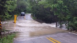
Then, a couple of months later, coming down the same road, I saw this . . . and became a believer. (BTW: these signs are all over the place in Texas.)
View attachment 14695
- Joined
- Jun 27, 2017
- Messages
- 1,508
Flood gauges are placed at all roadways with underpasses, sometimes with warning lights and RR arms, Stop signs can be marked 1,2,3 feet above gutter level. All uniformed members get boat/airboat training. Companies should be aware what water level the exhaust and electrical system on their rig can "tolerate".
The Civil Engineering Department at Rice University is developing a computer program for GIS display of real time and predicted flooding that can be pushed out to first responders on the street.
The Civil Engineering Department at Rice University is developing a computer program for GIS display of real time and predicted flooding that can be pushed out to first responders on the street.


